
Exploring
Rural
Public
Space
A Nordic Travelling Transect
In June 2019, a group of researchers travelled to three places far from the urban centres in Denmark, Sweden, and Norway to explore new public spaces emerging in the face of rural decline. We went in search of new spaces created by or together with local people, creating new common uses in disused or underused built environments and landscapes. In our previous research we had observed that the design of such public spaces plays an increasingly important role in the development of attractive and liveable rural living environments in the three Nordic countries – despite different spatial and institutional conditions and different national spatial development policies. But what does this mean on the ground? With our travelling transect we wanted to learn from different places and people and gain practical embodied experiences about emerging new public spaces, how they are created, used, and managed and how they transform rural places and everyday life.
The three places we visited reflect different spatial conditions of remote Nordic rurality. From the popular Danish surf spot Klitmøller on the North Sea coast in Thy with a hinterland of flat and (in the Nordic context) relatively densely populated farmland to the Swedish (former) mill town of Fengersfors in the forests of Dalsland to the Norwegian fishing town of Vardø on the Barents Sea above the Arctic Circle.
This website offers impressions from Klitmøller (DK), Fengersfors (SE) and Vardø (No) in the form of a travelogue in text, interviews, photos, and videos as well as the archive of an exhibition we created to share and discuss our insights with local key actors in a joint follow-up workshop in Copenhagen in December 2019.
6 June 2019, Travelling to Klitmøller (DK)
7 June 2019, Klitmøller: Collective transect and interviews
Rasmus Johnsen: Cold Hawaii and the landing place
Thilde Kielsgaard Heidemann: Cold Hawaii inland and the new surf spot at Vandet Sø
Martin Eigenbroth: The Ny Foreningsvej from a citizens perspective
8 June 2019, Exploring the regional context in Thy
9 June 2019, Klitmøller: Individual transects
10 June 2019, Travelling from Klitmøller (DK) to Fengersfors (SE)
Björn Ohlén: Fengersfors in the regional planning context
11 June 2019, Fengersfors: Collective transect and interviews
Marcus Lindén: Fengers Husrum and the meeting places in Fengersfors
Coffee at the local shop with Elsa Dahlstrand, Byalaget
Monica Lindstrand and Karin Hedborg: Hållbara platser in Fengersfors
Dinner with Not Quite at Fengers Husrum
12 June 2019, (Morning), Fengersfors: Regional connections
Anders Lindgrén: Steneby School and Mötesplats Steneby
12 June 2019, (Afternoon), Fengersfors: Individual Transects
13 June 2019, Fengersfors: Municipal Connections
14 June 2019, Travelling from Fengersfors (SE) to Vardø (NO)
15 June 2019, Vardø: Collective transect and interviews
Tormod Amundsen: Shelters for bird watchers
Svein Harald Holmen: Vardø Restored and Fiskekajen
16 June 2019, Vardø: Individual transects
17 June 2019, Alonza Garbett: Vardø Municipality
18 June 2019, Travelling home from Vardø
Klitmøller is a small town in the far northwest of Denmark, on the North Sea coast of the Thy region, about a five-hour drive from the capital Copenhagen. Klitmøller is part of Thisted, a large rural municipality with about 43,000 inhabitants and an area of 1,074 km2 covering the entire Thy region. More than half of the population live in settlements with less than 1,000 inhabitants. Like in many other peripheral rural areas in Denmark the population is shrinking and ageing, and private and public service levels are threatened in many places. But Thy also has unique nature especially in the Thy National Park created in 2007. The North Sea coast also offers exceptional wave conditions for windsurfing known as Cold Hawaii. As the “capital of Cold Hawaii”, Klitmøller is in many ways an atypical place in Denmark’s rural periphery and the population has grown from 807 in 2010 to 1,114 in 2022.
Originally, the town was a shipping place. The name ‘Klitmøller’ (literally ‘mills in the dunes’) goes back to the 17th century when three watermills surrounded by dunes were located along the Klitmøller stream. The mills ground grain for shipment to Norway. Until an industrial fishing harbour was built in nearby Hanstholm in 1967, Klitmøller was a thriving fishing town. Fishing is still taking place, but at a very low level, from boats pulled ashore on the beach like in the old days. In the late 1970s the first surfers came to Klitmøller and since then the town has grown into an international windsurfing destination and attracted an international population. The historical fishing milieu around the landing place is well preserved and still active, but in 2012 it was substantially transformed to accommodate surfers and other recreational users. This was part of a strategic rural development project for ‘the good life at the seaside’ inspired by the 2007 Cold Hawaii masterplan, an NGO-based strategy for surf destinations in Thy. The association Friends of Cold Hawaii was a driver in this process, in collaboration with many other local associations and Thisted municipality. During our site visit we are interested in exploring the new public space around the landing place and to learn more about follow-up planning initiatives in Klitmøller and at the municipal level in the Thy region.


Guesthouse Klitmøller (Home in Klitmøller) Anne Tietjen, 2019
6 June 2019: Travelling to Klitmøller (DK)
The two researchers from the University of Copenhagen (DK), Anne Tietjen and Gertrud Jørgensen, meet Nils Björling from Chalmers (SE) at the car rental in Copenhagen. Together we drive to Aarhus where we pick up Thomas Juel Clemmensen from UiT (NO). From Aarhus we drive to Aalborg Airport where we meet with Inger-Lise Saglie from NMBU (NO) and our research assistant, Rasmus Weitze Pedersen, who lives and works as a municipal planner in Aalborg. From Aalborg we all drive to Klitmøller and arrive at our accommodation, the Guesthouse Klitmøller, around 19.00.

Klitmøller Landing Place,
Rasmus Weitze Pedersen, 2019
7 June 2019:
Klitmøller collective transect and interviews
In the morning, we meet with Rasmus Johnsen at Co-work Klitmøller right next door to our guest house. Rasmus is an entrepreneur, development consultant and co-founder of Friends of Cold Hawaii . First, Rasmus introduces Cold Hawaii and the background of surfing in Klitmøller and along the North Sea coast of Thy. Then, he takes us on a walk and talk along the recently remeandered part of the stream Klitmøller Å, over the dunes and along the beach to the landing place, which was converted in 2012 into a shared meeting and activity space for surfers, fishermen and other water-related recreational activities. A new 300-meter-long concrete walkway – the so-called Foreningsvej (association path) – behind the fishermen's huts along the beach solved long-standing spatial conflicts between surfers and fishermen, created access for all and new places to stay and rest. We end our walk on the public rooftop of Hummerhuset, a clubhouse shared by surfers (the North Atlantic Surf Association (NASA) and the Biological Association for Northwest Jutland (BFN).


Gerd Dam
Rasmus Weitze Pedersen, 2019


Masterplan Ny Foreningsvej
Thisted Kommune (2018) Ny Foreningsvej: En naturlig forbindelse i Klitmøller.
Gerd Dam: The Ny Foreningsvej
At noon, we meet with Gerd Dam at Hummerhuset. Gerd works as a planner at Thisted Municipality and is project manager of the ongoing Klitmøller area renewal , which builds on Helhedsplan 2026, a collaboratively developed master plan for Klitmøller as the capital of Cold Hawaii.
Gerd takes us on a walk and talk through Klitmøller and along the planned Ny Foreningsvej (the new association path) along the Klitmøller Å. This new path with new places to stay along the stream is a central project in the area renewal. It will begin next to the supermarket on the main street, which is a central informal meeting place in Klitmøller. The path will reconnect the town with the Klitmøller Å, allow public access to the stream and create a safe foot path from the town centre to the local school. Gerd also tells us that a possible extension of the path from the local school into the National Park and to a local beginners’ surf spot at the lake Vandet Sø is already being discussed.


Overview map Cold Hawaii Inland
Spektrum Arkitekter, NORRØN Arkitekter, ISC Rådgivende Ingeniører (2019). Streger i landskabet. Dispositionsforslag, 11.01.19
Thilde Kielsgaard Heidemann:
Cold Hawaii Inland and the new surf spot at Vandet Sø
At 14.00, we meet with Thilde Kielsgaard Heidemann at the local school. Thilde works as a development consultant at Thisted Municipality and is project manager of the development project Cold Hawaii Inland. She tells us about the plans for expanding the success of the Cold Hawaii surf spots at the North Sea coast to other places in the inland of the municipality, including a new surf spot for beginners at Vandet Sø, a lake near Klitmøller, and several spots along the Limfjord coast.
After the meeting with Thilde we drive to Vandet Sø to visit the new surf spot there. This afternoon there is no wind, and we meet only one hiker who is taking a break at the pier.
Martin Eigenbroth:
The Ny Foreningsvej from a citizen’s perspective.
In the late afternoon, we meet with Martin Eigenbroth at his home in the dunes right behind the landing place. Martin is a local citizen who is involved in the local area renewal in Klitmøller. He tells us about the Ny Foreningsvej (the new association path) as a part of the Klitmøller area renewal and the master plan for Klitmøller, Helhedsplan 2026.


Thy photo gallery.
Anne Tietjen, 2019
8 June 2019, Klitmøller:
Exploring the regional context in Thy.
On our second day in Klitmøller, we explore the regional context in Thy.
We visit Cold Hawaii surf spots along the North Sea coast at Hanstholm harbour and the landing places at Nørre Vorupør and Stenbjerg.
We also travel to places where Cold Hawaii Inland is being developed – Synopal's former industrial harbour in Thisted, the forthcoming new National Art Gallery branch, SMK Thy, in Doverodde and a Limfjord surf spot in Krik.
In the afternoon we take a walk in Thy National Park around Isbjerget (the Iceberg), where a land art project with white stones marks the ascent and guides the view over the wild dune landscape.
In the evening we eat dinner at Hanstholm Madbar , a popular local restaurant, mini hotel, and spa next to the lighthouse in Hanstholm that was developed with financing from the EU Rural Development Programme.


Connections between town, beach, and sea, mapping
Nils Björling, 2019


Connections between town, beach, and sea, photos
Anne Tietjen & Niels Björling, 2019


Following Klitmøller Å
Thomas Juel Clemmensen, 2019
9 June 2019, Klitmøller: Individual transects
On our third day in Klitmøller, we pursue Individual transects following our specific interests.
Anne and Nils take a long walk through the town, along the beach and the landing place and across the dunes to explore the connections between the town, the beach, and the sea.
Thomas walks along Klitmøller Å and the trajectory of the forthcoming Ny Foreningsvej (new association path). Beginning at the historical site of an eel coffin outside the town, he follows the stream from west to east, registering how it changes character from public frontside to private backside through the town.
He finds it remarkable that the last traces of the dam at the old watermill behind the guesthouse Klitmøller were removed to create a fauna passage. While the project for the Ny Foreningsvej (the new association path) explicity aims to reconnect the town with its historical origins along the stream, the plan to restore better ecological conditions in the stream does the opposite.
Rasmus once more explores the landing place, where the sea around Ørhage today is filled with surfers.
10 June 2019: Travelling from Klitmøller (DK) to Fengersfors (SE)
In the morning we drive from Klitmøller to Frederikshavn to take the ferry to Gothenburg. The trip takes three hours and thirty minutes.


Chalmers University
Nils Björling, 2019


Björn Ohlén
Rasmus Weitze Pedersen, 2019
Björn Ohlén: Fengersfors in the regional planning context
Upon arrival in Gothenburg, we drive to Chalmers University where we meet Björn Ohlén. Björn is a process manager at Västra Götalandsregionen, the administrative region where Fengersfors is located. He explains how the region works with platsutveckling (place development), specifically through the project Hållbara Platser (sustainable places) which aims to support collaborative local development across business sectors and runs until the end of 2019 (total volume SEK 6 million). Fengersfors is one of the places in this project. The region provides a local process manager appointed by the local community. By now, each place has made a local development plan, but there is a lack of funding and organisation. In Fengersfors, the region has also supported the local artist group Not Quite , who have revived the disused paper mill in Fengersfors, which now attracts 75,000 visitors a year. Not Quite has developed a vision for a new mill town (Den nya bruksorten, 2018 ) centred on the mill, while the local development plan focuses on other public spaces inside the town. For now, the two plans are not coordinated.


Fengers Husrum
Rasmus Weitze Pedersen, 2019
We eat dinner in Gothenburg before we continue our journey to Fengersfors. Around 23:00 we arrive at Fengers Husrum , a small bed and breakfast, which is our accommodation and field base in Fengersfors for the next three days.
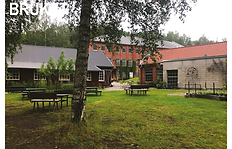
Fengersfors , a small town with 300 inhabitants is situated in a varied forest- and small scale agricultural landscape in Dalsland. The settlement developed around an ironworks in the late 1700s. The iron industry formed an industrial network of several mills that used timber from the forest and the rivers and lakes for power and transportation. The ironworks closed in 1884, but a second industrial period began in the early 20th century around a paper mill, which had to close in 1978 despite support from both the Swedish state and Åmål Municipality. Fengersfors is a representative example of late 20th-century industrial decline in the Swedish countryside. Today, the industrial infrastructure and buildings of the closed paper mill are being used for new production and services. One of the main drivers behind the redevelopment of Fengersfors Bruket is Not Quite, a cultural centre and network of artists, designers and craftspeople who have taken advantage of the old paper mill and made it one of the most popular tourism destinations in Dalsland. The local initiative was supported by regional initiatives to preserve and develop the regional industrial cultural heritage. Fengersfors is also one of the places that are part of the regional planning initiative for sustainable local development, Hållbara platser. We are interested in exploring the new public spaces that have been created at Fengersfors Bruket and how they relate to the development of the town of Fengersfors, the community and local meeting places on the one hand and to rural/urban functions, activities and public spaces in Dalsland on the other.


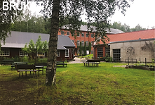


Fengersfors town
Anne Tietjen, 2019


Fengersfors town
Anne Tietjen, 2019


With Marcus Lidén at Fengers Husrum
Rasmus Weitze Pedersen, 2019


Bathing pier
Anne Tietjen, 2019


Common sauna
Nils Björling, 2019


Lakeside bathing spot
Nils Björling, 2019


Fengersfors sports club
Nils Björling, 2019
11 June 2019, Fengersfors: Collective transect and interviews
In the morning, we take a walk through Fengersfors to the lake and the lakeside bathing spot, coming by the stream (fors), which gave the town its name and still supplies Fengersfors with hydroelectric electricity.
Marcus Lidén: Fengers Husrum and the meeting places in Fengersfors
At 11.00 we are back at our accommodation for a talk with the owner of Fengers Husrum, Marcus Lidén. Marcus is a member of the local artist group Not Quite and teaches upholstery at Steneby School in Dals Långed, where many Not Quite members trained, and some now teach. He arrived in Fengersfors 9 years ago (in 2010) and first ran a café. Fengers Husrum used to be a butchery. He renovated and converted the house himself into a B&B together with family and friends. In his opinion it is important to have a small local accommodation in a rural place like Fengersfors. There live only 50,000 people in the whole Dalsland region, and Fengersfors might be the only one with newcomers. There are maybe 20 active Not Quite artists who usually live just outside of town. He adds: If you get a workspace, you also get a place to live.
Speaking of meeting places, Marcus highlights the lakeside bathing spot with a common sauna in the forest – the location of which has been contested between Not Quite members and other locals. The bathing spot is important and attracts visitors all the way from Åmål. Bruket (the mill) is also a meeting place – there is a café, bakery, offices, and workshops here – but not all locals use it… The local shop (across the street from the mill) is a meeting place. Another important meeting place is Fengersfors sports club (FIK). There is some activity at the local ball field, and the community house, Folkets hus, can be rented for confirmations. There are many meeting places, so people are divided (among them)… But the midsummer party takes place at the bathing spot and there is only one party in Fengersfors.
The local shop
Anne Tietjen, 2019


Elsa Dahlstrand
Rasmus Weitze Pedersen, 2019
Coffee at the local shop with Elsa Dahlstrand Byalaget
At 14.00, we meet Elsa Dahlstrand at the local shop across the street from Bruket. Elsa is a member of Byalaget, the local community council. She tells us about the activities of the local community council, for example, to organise the village christmas tree and shows us around the shop which also serves coffee and is an important informal local meeting place. Keeping the shop is essential for community life in Fengersfors. Before we go we all have a cup of coffee together at the shop.


Meeting Monica and Karin about Hållbara platser
Rasmus Weitze Pedersen, 2019
Monica Lindstrand and Karin Hedborg: Hållbara platser in Fengersfors
At 15.30, we meet Monica Lindstrand and Karin Hedborg at Karin’s home in Fengersfors. Monica and Karin are the local process managers of Hållbara platser appointed by the community and financed by Västragötlandsregionen. Karin and Monica tell us about their ideas for the development of Fengersfors. Their focus is on the development of the town and meeting places in the town. They are interested in developing new attractive housing and they are concerned about the closure of the local school and keeping the local shop. Speaking of meeting places, they want a new playground near the ball fields. The most important local meeting place for them is the bathing area at the lake, where the midsummer party takes place. They want to cover the open-air dance floor so that you can use it for a longer period of the year. When asked about Bruket, they tell us that they don’t come there very much. Monica used to work at the factory. They sometimes buy bread at the bakery and Karin has participated in a workshop by a Not Quite artist.


Den Nya Bruksorten
© Not Quite ekonomisk forening, 2018
Not Quite: Fengersfors Bruket
At 16.30, we meet with Not Quite members Karl Hallberg and Marcus Haraldson at the organic bakery inside Bruket for a tour of the disused mill that Not Quite has partially revived with new uses. We are shown the garden of the café, where the artists have removed the rubble pavement, seeded grass and set up seating places between sculptures made from recycled materials. We also look inside the wood and metal workshop and meet carpenter Elin Guldåker, followed by a tour of the Museum of the Paper Industry in the former production building, which also serves as an art gallery. At the back of the museum, we walk through overgrown ruins and marvel at the fact that these rooms are not locked and accessible, albeit difficult to find.
Karl Hallberg tells us that it was the character of the industrial site and the diversity of available spaces plus the possibility of affordable housing in Fengersfors that attracted former students and teachers at Steneby School to establish studios and workshops here and to found Not Quite back in 2002. From the start it was an ambition to create an open inviting environment also for visitors. Currently, Not Quite are working on reorganising the ownership of the mill and they made a development vision for a new mill town (Den nya bruksorten) in 2018.


Dinner with Not Quite
Nils Björling, 2019
Dinner with Not Quite at Fengers Husrum
In the evening we cook dinner for Karl Hallberg, Marcus Haraldsson, Malin Robertsson Harén and Vera Telemo from Not Quite at Fengers Husrum.


Steneby School
Rasmus Weitze Pedersen, 2019


Steneby school
Rasmus Weitze Pedersen, 2019


On the shores of Dals Långed
Rasmus Weitze Pedersen, 2019
12 June (morning) Fengersfors: Regional Connections
Anders Lindgrén:
Steneby School and Mötesplats Steneby
In the morning of our second day in Fengersfors, we explore the regional context in Dalsland and visit Steneby School, about 40 minutes’ drive from Fengersfors. At Steneby school we meet with Anders Lindgren, who is the head of Mötesplats Steneby. Anders tells us about the history of Steneby school, which was established in the 1930s as an arts and crafts school in the countryside and today also houses a dependency of Gothenburg University. In particular, he presents the work with Mötesplats Steneby (Meeting place Steneby), an ongoing initiative that supports (projects for) cultural life in Dalsland – including the work of Not Quite in Fengersfors.
We are given a tour of the school and end our visit at a physical meeting point built by international and Swedish students on the shore of Dals Långed with a garden, sauna, outdoor kitchen, and viewpoint overlooking the lake.


Frontsides and backsides
Thomas Juel Clemmensen, 2019


Following the art walk
Anne Tietjen, 2019
12 June (afternoon), Fengersfors: Individual Transects
In the afternoon of our second day in Fengersfors, we pursue individual transects following our specific interests.
Thomas explores frontside and backside situations between Knarrbysjön and Bruket, following the stream from the lake to the mill.
Overall, he finds that not many elements in the area draw attention to the stream. In many situations, it appears as a hidden backside. In comparison to its historical significance as the basis for the establishment of industrial production, it receives little attention. Working with the stream as a new connection between Bruket and its surroundings has great potential.
Anne follows an art walk from Not Quite along the boundary between the mill site and the creek. She meets the artist, Cordula, and finds a secret place at the bottom of a hidden staircase.
Rasmus explores the backside of the mill site and discovers a hidden path from the overgrown ruins to the ball fields.


Åmal Municipality
Rasmus Weitze Pedersen, 2019


Åmal Municipality
Rasmus Weitze Pedersen, 2019
13 June (morning), Fengersfors: Municipal connections
In the morning we drive to Åmål, the seat of Åmål Municipality to which Fengersfors belongs. At Åmål Stadshus we meet Stefan Jacobson, Fatima Åhl-Sjöberg, and Anna Hjelmbjerg. Stefan is kulturchef (cultural director); Fatima and Anna work as municipal planners. They tell us that Åmål Municipality has SEK 1 million available each year for strategic cultural development, which is currently being used for three main projects, one of which is Not Quite in Fengersfors. Among other things these funds aim to promote new meeting places and develop existing ones, and one of Not Quite’s agreed tasks is to act as a host for tourists.
The regional development project Hållbara Platser is becoming more and more important for the municipality´s cultural strategic work because anchoring broad local support is crucial for granting funding for culture. In Fengersfors, Hållbara Platser has helped shift the focus from the individual Not Quite initiative to the town of Fengersfors. Indeed, the regional project pointed to a dilemma: should the municipality support Not Quite or Fengersfors as a whole, or ask Not Quite to contribute to the development of the local community?
The planners tell us that Bruket in Fengersfors is for sale and that there has been established a collaborative platform to buy it including Not Quite, the municipality, the region, the local community and Steneby Platsutveckling. The municipality would like to be part of the ownership group and has four objectives for the future development of the factory site: a cultural meeting place, historical preservation of the buildings, tourism, and business development.
The planners inform us that there is not yet a detailed plan for the physical development of the factory site in Fengersfors. When the researchers suggest that new ownership and physical redevelopment could represent great potential to strategically think about the development of the town of Fengersfors and the mill together, it sparks a lively discussion about physical changes as a catalyst for local development.
14 June 2019, Travel Day 3 from Fengersfors (SE) to Vardø (NO)
In the morning we drive from Fengersfors to Oslo Airport, where we park our rental car. At 17.55 we fly from Oslo to Kirkenes. The flight takes two hours. At 21.00 we fly from Kirkenes to Vardø with a stopover in Vadsø. This flight takes 35 minutes. Vardø Airport is on the mainland of the Varanger Peninsula. A taxi takes us through the tunnel to the island of Vardøya. Around 22.30 we reach our accommodation, an AirBnB apartment on Strandgatan at the North Harbour. At this time of the night it is still light and the sun does not set at all as long as we are in Vardø.
Vardø is located on the island of Vardøya in the Barents Sea in northeastern Norway. Together with Hammerfest, it is the oldest town in Northern Norway with a settlement history dating back to the Stone Age. Vardø was granted town status in 1789, due to its importance for the Pomor trade with Russia. In the 1600s and 1700s, Vardø was a center for witch trials, to the commemoration of which the Steilneset Memorial was established in 2011. By the beginning of the 1900s Vardø had about 3,000 inhabitants. During the Second World War, a central part of the town was destroyed in a Soviet bomb attack. However, when the German occupying forces abandoned Finnmark, Vardø was the only town spared complete destruction, and many historical wooden buildings survived. In the 1980s and again in the 1990s, Vardø was hit by a decline in the fishing industry and the population halved until 2010. Today , Vardø has about 2,000 inhabitants and many historical buildings are empty and derelict.
Despite its small size and peripheral location Vardø has a rich heritage and – most importantly – a unique preserved pre-war architecture. This has been a backbone for Vardø Restored, a local development strategy based on cultural heritage in commercial ownership initiated by Varanger museum (2012-2016). Buildings were restored and put to new uses by a partnership between owners, the government and a multidisciplinary expert team. In 2012 the Koma fest street art festival brought local and international attention to the ruins around the harbour. In recent years Vardø has grown into an international birding destination in the Varangerhalvøya National Park and was put on the map of the Norwegian Scenic Routes with the Steilneset Memorial designed by the Swiss star architect Peter Zumthor and the French-American artist Louise Bourgeois. We are interested in exploring new public spaces and spaces of public concern emerging in Vardø. What new meeting places were created by Vardø Restored and how are tourist destinations for bird watchers and the Steilneset Witch Memorial connected to local everyday life?


Biotope Architects: Hornøya Shelter
Thomas Juel Clemmensen, 2019


Biotope Architects: Shelter on parking space in Vardø
Anne Tietjen, 2019


Biotope Architects: Shelter at southern tip of Vardø
Anne Tietjen, 2019
15 June, Vardø: Collective transect and interviews
Tormod Amundsen: Shelters for birdwatchers
In the morning, we walk from our accommodation around the harbour to the office of Biotope, a local architecture firm to meet with the founder Tormod Amundsen. Tormod is an architect and a passionate birder, and it is his passion for bird watching that has brought him to Vardø. Biotope’s projects bring together an interest in nature, nature experiences and architecture. With Birding Varanger, they have made a guide to the best bird sites in Arctic Norway. Locally in Vardø and on the neighbour island Hornøya Biotope has designed three shelters for birdwatchers – which have developed into meeting places for locals, tourists, and birds.
After the meeting with Tormod we take the boat to Hornøya to go birdwatching and visit one of Biotope’s shelters which to our surprise has been taken completely over by nesting birds.


Almenning with Svein Harald
Rasmus Weitze Pedersen, 2019


Almenning with Svein Harald
Anne Tietjen, 2019


Restored by Vardø Restored
Anne Tietjen, 2019


Almenning with Svein Harald
Anne Tietjen, 2019


Koma Fest: Street art on derelict building
Anne Tietjen, 2019
16 June 2019, Svein Harald Holmen: Vardo Restored and Fiskekajen
In the morning Svein Harald Holmen visits us for an interview at our AirBnB and a walk and talk through Vardø. Svein Harald is co-initiator and project leader of Vardø Restored, a people centred initiative for the restauration and reuse of empty historical buildings.
He came back to Vardø in 2003 after five years abroad and found the town radically changed. After the fishing industry collapsed in the 1990s there had been mass bankruptcies, and now the town was plagued by empty shops and physical decay of abandoned houses. One had to do something!
After some experiments with a small summer café and local festivals, he became involved with placemaking in Hamningberg based on cultural heritage as a resource. This created many conflicts at first. Back then many locals experienced that ‘first we have to give up fishing and move away for work and then the authorities come and list my building as heritage’. The Hamningberg project developed an alternative approach with collaborative workshops that created a shared platform and understanding between property owners and authorities and helped interested owners with funding applications and guidance for heritage restoration. This experience became the basis for Vardø Restored, which mainly helped people to apply for funding, but there were also carpenters to help with practical matters. The project received a lot of attention, won prizes and grew bigger, but did receive the last big funding from Riksantikvaren (the National heritage agency) in 2015.
Now in 2019, Vardø Restored consists of Svein Harald and Brona Keenan who run it as a business in the local fishing association's buildings – which have been restored and are reviving the traditional local fishing culture and also work as a local meeting place. Svein Harald has started fishing himself to earn money and be independent of funding applications. He has learned fishing from scratch with help from retired local fishermen, and the association is considering starting processing the fish themselves.
Besides Vardø Restored, Svein Harald and Brona are involved in the organization of the Koma Fest which started in 2012 with a visit of the street artist Pöbel from the Lofoten islands. Ten international street artists painted on buildings and ruins all over Vardø with broad support from the local community.
After the meeting, we take a walk through town to visit the new fishing place and other buildings restored with the help of Vardø Restored. On our way we also pass by some of the buildings painted by the street artists during the Koma Fest
Svein Harald in front of the bakery
Anne Tietjen, 2019


Almenninger along the harbour
Nils Björling, 2019


Fiskekajen
Inger-Lise Saglie, 2019

The birding shelter on the parking space
Thomas Juel Clemmensen, 2019
16 June 2019, (afternoon), Vardø: Individual transects
In the afternoon of our second day in Vardø, we pursue individual transects following our specific interests.
Nils explores the relationships between almenninger (common landing places) and the structure of the town along the harbour.
Inger-Lise revisits Fiskekajen, the restored fishing place.
Thomas visits the Biotope bird shelter on the parking space at the eastern tip of Vardøya.
Rasmus explores the Tusenårsstien (the millennium path), a round trip from the ferry port of the Hurtigruten cruise ships around the southern Ptip of the island, Steglneset, past one of the bird shelters designed by Biotope to the memorial for the local witch hunting, Steilneset, and the fortress back to the harbour.

Vardø Municipality
Rasmus Weitze Pedersen, 2019


Skagen fireplaces
Anne Tietjen, 2019


Steilneset memorial
Rasmus Weitze Pedersen, 2019


Dilapidated buidlings
Rasmus Weitze Pedersen, 2019
Demolished buildings
Rasmus Weitze Pedersen, 2019
17 June, Alonza Garbett: Vardø Municipality
17 June 2019, Alonza Garbett: Vardø Municipality
In the morning, we walk down to the municipal hall to meet Alonza Garbett. Alonza is technical director at Vardø Municipality and has previously worked as an architect at Biotope.
Alonza came to Vardø in October 2012. He had planned to stay for a year but then met his wife and made family in Vardø. “You love it or you hate it here”, he says, “there are no offers like in the big city, you have to be active yourself.” When he arrived, there were several discos and a bowling hall, but they are all closed now. Today, there is very little for younger people. There is the swimming pool, the sports clubs, and the cinema once a month – all gathered in the municipal hall and culture centre. The main public space is Strandgata, where the pomorfestival takes place. But the municipality does not prioritise public space; the weather is not for outdoor public life.
Speaking of meeting places, he says that the memorial to the local witch hunting [Steilneset] is not a place where people gather. Few groups try and do something at Skagen just outside town where there are 4-5 fireplaces and a lit cross-country skiing trail. There are people there all day, but it is not a meeting place as such, but rather a walking place.
“You do not have urban life understood as an organic grouping of people – here people are together because they know each other and chose to be together. Public life à la Jane Jacobs does not exist.”
Speaking of business development and the fishing industry in Vardø, Alonza says that the municipality has demolished two old, disused production buildings along Strandgata to prepare for new investments. If there was fish processing on location, the town could get more fishing quota, he explains.
The primary current planning task is to create a new municipal development plan. There are many empty houses that are so dilapidated that they are dangerous and should be demolished as soon as possible. However, this is costly, and the muncipality has limited resources for demolition. Another issue related to this is the Kulturminneplan (the cultural heritage plan), according to which everything built before 1945 is cultural heritage. But if there are four buildings of the same type along the street, why should we preserve them all? asks Alonza. It's very difficult [for the community] to prioritise which buildings should be preserved and which shouldn't.


Ferry coming into port
Anne Tietjen, 2019


Waiting for the ferry
Anne Tietjen, 2019
18 June 2019, Travelling home from Vardø
At 3.30 in the morning we leave Vardø by boat with Hurtigruten to Kirkenes. The cruise along the coast of the Barents Sea is spectacular. At 9.00 we land at Kirkenes harbour from where we take a taxi to the airport. At 11.35 we fly out from Kirkenes to Oslo, where we arrive at 13.35. At Oslo Airport we part ways. Thomas and Rasmus fly on to Tromsø and Aalborg. Inger-Lise takes a local train home. Nils travels to Gothenburg by train. Gertrud and Anne pick up our rental car at the parking lot and take the night ferry from Oslo to Copenhagen.


Follow-up workshop and exhibition, University of Copenhagen
Anne Tietjen, 2019


Follow-up workshop and exhibition, University of Copenhagen
Anne Tietjen, 2019


Ny Foreningssti, bridge and shelters on the main street
Anne Tietjen, 2020


Ny Foreningssti, added bridge to the churchyard in the dunes
Gerd Dam, 2020
Epilogue
In December 2019 the researchers organised a follow-up workshop and exhibition of our findings at the University of Copenhagen to discuss Nordic perspectives for rural public space development. To this workshop we invited some of the key stakeholders from Klitmøller, Fengersfors and Vardø to get to know each other, share their experiences and expand the research network to practitioners.
In 2020 Nils co-organised the Rurban Planning Talks in Mariastad in Sweden, a meeting of researchers and planning practitioners, where Anne, Vera Telemo and Ylva Frid from Not Quite contributed to a common workshop on local strategic capacity for long-term development of the designed living environment.
Until 2023 Anne and Gertrud are working on a research project about quality of life through innovation in the built environment in rural areas far from urban centres in Denmark. In this context they have revisited Klitmøller several times. Anne has co-edited an international anthology on Rural Quality of Life and Anne and Gertrud and Nils have contributed chapters to the book which will be published in 2023.
In Klitmøller The Ny Foreningssti opened to the public in January 2020 and since then several new elements have been added and it is currently being extended to Vandet Sø. In 2022 the Klitmøller Borger- og Erhvervsforening (citizen and business association) and Thisted municipality made an updated master plan for Klitmøller which was necessary since the town continues to grow in population.
In Fengersfors Not Quite continues working on the development plan for the mill site.
In Vardø Svein Harald Holmen continues advising local owners who want to restore and reuse their historical buildings. But his main activity today is fishing.
Thomas continues his practice of walking along rivers to explore landscape transformation.
The project Exploring Public Space in Rural Transformation is supported by The joint committee for Nordic research councils in the humanities and social sciences (NOS-HS) and conducted by researchers from the University of Copenhagen (DK), Chalmers University of Technology (SE), The Norwegian University of Life Sciences (NO), and UiT The Artic University of Norway (NO). Unless where otherwise noted, the content of this website is distributed under the Creative Commons License Attribution-NonCommercial-ShareAlike 4.0 International (CC BY-NC-SA).

